Showing posts with label Glacier Bay National Park. Show all posts

Thursday, November 11, 2010

Fairweather Mountains


It has been over 2 months since I left Glacier Bay... I was fortunate to see the beauty of the remote park in Southeast Alaska. Now I'm here in the Anchorage area and processing thousands of photos from Glacier Bay. I've neglected to update my blog for the past couple of months... Here is a final posting from Glacier Bay: Fairweather Mountains.

Fairweather Mountain Range, includes Mount Fairweather at 15,300 ft and other majestic high peaks in Southeast Alaska. The mountain range stretches 70 miles long across Glacier Bay National Park & Preserve. Hundreds of major glaciers starts from these mountains.

In typical Southeast Alaska weather, overcast and rain, the entire Fairweather Range can be hidden under gray clouds. It is a rare and exciting occasion when the sky is clear and the mountains show off their beauty.

It was one of those evenings, I was photographing the mountains during sunset. After long hours of day light, the sun slowly shifted to the peaks. The mountains were in warm orange light. Then, when the sun dipped behind the mountains, the thin clouds above the peaks painted them in crimson. The water in front reflected the colors of sunset; vivid red. Fortunately, sunset takes longer in the northern latitude. It was the most amazing sunset since my arrival in Glacier Bay. I heard howling of wolves all night under the Milky Way.

The sky was still clear the next morning. Unlike typical foggy mornings here, the entire Fairweather Mountain range in front of my camp slowly turned the twilight sky rosy pink in all directions. Then, as the first sun peaked through, the tip of Mt. Fairweather lit up in magenta. The light slowly shifted down, then lit the second highest summit in view, Mt. Crillon. Slowly and surely, the entire Fairweather Range was glowing. Thanks to the longer sunrise in Alaska, I had enough time to capture each mountain and the entire range close up.

Here are the sunset images from other days.


Mount Fariweather from sky...

Sunday, September 12, 2010

Kayak Camping Trip in Glacier Bay #3


After exploring McBride Glacier and the iceberg filled lagoon, four of us paddled hard to the south. Our kayak was gliding smooth in the calm fjord ocean under the beautiful blue sky.

Our second night was on the beach of Goose Cove with a view of Mt. Wright.

We were shocked to discover two good sized holes surrounded by bear prints...the holes were bear's day beds! Wherever we stayed, there were signs of bears in this remote Alaskan wilderness.

The bugs in Alaska were worse than bears. During the sunset, clouds of mosquitoes and flies attacked us... There is a joke that the "Alaskan state bird is a mosquito." (The true Alaskan state bird is the Ptarmigan.)

It was misty the next morning...heavy clouds covered up the entire bay and Mt. Wright as well as the mountains on the other side of the fjord hid under the gray clouds. The misty rain quietly fell all day while we were paddling. We were soaking wet.

The final night of camping was on a small island. It wasn't fun to set up a tent in the rain...this is part of the Southeast Alaskan experience.

It was raining hard the next morning too... We waited for the boat to pick us up in Sebree Island. The boat arrived on time. It was great to sit in the dry warm cabin and use a "real" bathroom. However, I already miss the wilderness experience I just had.

Wednesday, September 1, 2010

Kayak Camping in Glacier Bay #2 - Riggs Glacier and McBride Glacier

It was a mysteriously foggy morning at Riggs Glacier... The white air covered up the canyon in Muir Inlet. What a change from the beautiful sunset!
Slowly that morning, the fog lifted... The white icefall of Riggs Glacier began to show in a white veil. This was the time when mother nature showed me a special moment!

Several streams from the melting water that ran through the mud flat, created abstract natural art.

The fog dissipated under the blue sky. Another clear day in Southeast Alaska.

Paddling south to McBride Glacier. McBride Glacier has been retreating in past decades but it is still actively calving chunks of icebergs into the sea. The lagoon was full of large icebergs that are the size of cars and homes. The white icebergs drifted onto the shore. The landscape was like another planet.

Saturday, August 28, 2010

Kayak Camping in Glacier Bay #1

Glacier Bay is known as a "marine park." The main part of Glacier Bay National Park & Preserve is ocean. Only 200 years ago, the majestic Grand Pacific Glacier covered the entirety of modern day Glacier Bay. The glacier retreated rapidly and left a deep water way called a fjord. There are 16 glaciers, numerous inlets and countless islands in Glacier Bay, however, this spectacular landscape is only accessed via the water ways.
I have been exploring the natural environment in Glacier Bay for 2 months. I have been photographing the moss drenched rainforest, wild coastline, and bald eagles from the land, and additionally some glaciers and humpback whales from boats. Glacier Bay is a "Y" shaped bay; only the left side of the Y, west arm, can be accessed by power boats. Kayaking is the only way to explore the east arm, which includes Muir Inlet.
In early August, myself and three friends headed to the east arm paddling two double kayaks. White fog enveloped the bay and the surrounding mountains... even the green water of the bay was milky white in the fog. It was a mysterious morning for our adventure. I felt like I was in old Chinese paintings.

The mist burned out in the afternoon... the blue sky showed up above us. The wild mountains on both sides of the bay were majestic. White and blue glaciers capped some of the high peaks! The water that we were paddling in was emerald green like a tropical ocean. Paddling all day, many coves and beaches were passing behind. The water of the fjord was slowly narrowed as we progressed northward. After passing the first glacier in the east arm of Glacier Bay, we kept paddling to the north. I was excited to see an iceberg on the shore! Riggs Glacier where we would camp our first night was far away it seemed.

More icebergs were drifting in the water... but we kept paddling . It took us more than 3 hours to get there after seeing the glacier. When we passed McBride Glacier, which was giving birth of many icebergs, the surrounding terrain was dramatically changed! Fewer trees were on the shore now, and the canyon cliffs were lofty on both sides of the water.

After 27 miles of paddling, we arrived at Riggs Glacier. Riggs Glacier was calving icebergs into the water 50 years ago...however, it has been receding and no longer sends ice into the bay. Several melting streams run through large mud flats in front of the glacier. Two bald eagles were sitting on the rock to welcoming our arrival. Our view of the Riggs Glacier from the camp was unforgettable.

However, there were gigantic bear prints near our camp... I have never seen such huge prints!

Unlike Southeast Alaska where usually clouded, the sunset was gorgeous that evening...

Monday, August 16, 2010

Bald Eagle

Large numbers of Bald Eagles live in Southeast Alaska. Bald Eagles are often seen here in Glacier Bay National Park in Southeast Alaska. With a body length of upwards of 30 inches and a wingspan of 90 inches, it has been an impressive sight to see these large birds fly right above my head.

When the tide is low on Alaskan beaches, eagles can be seen scavenging. One particular bird I recently saw was feeding on a fish for a long time... Several others were looking at him and trying to steal the food in his claws. They often fight for the food.

Adult Bald Eagles have black bodies with a white head and tail with a yellow beak and legs as everyone knows them as the American symbol. Immature eagles are mixed colors with brown and white until 5 year old. When they reach maturity, their heads turn to "bald" just like some humans. I think whoever named "bald eagle" did a good job.

Tuesday, July 27, 2010

Humpback Whale

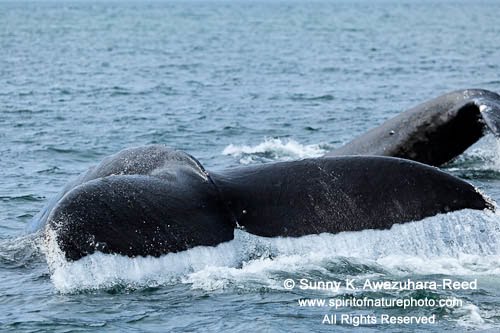
Thousands of humpback whales spend their time in Southeast Alaska during the short summer. They give birth in the South Pacific includes of Hawaii and also travel through Mexico during winter, and then migrate 2,800 miles north for feeding in Southeast Alaska.

I've been seeing many humpback whales since I arrived in Glacier Bay. I was paddling a kayak in a cove one afternoon and I saw a mother whale and a calf sleeping on the surface. Slowly, I was paddling toward the whale but they never moved. The huge smooth bodies were floating on the water...I could almost touch them! They were much larger than the double kayak which I was in! It was a peaceful moment for a while. Then, mother whale suddenly blew water, and the calf slowly woke up too. They gradually swam in the other direction... Then, the calf showed it's fluke and disappeared into the deep.
On another day, when I was on a small boat, a humpback whale came close to the boat. Suddenly, it breached in front of me! The whale's whole body leaped above the water with a roaring splash! It was only a short second, but a magical moment. I couldn't believe what I saw, but I caught the moment in my camera. Breaching can be for communication amongst the whales, but the true reason is still a mystery.

Humpback Whales often feed in groups in Southeast Alaska. When they swim together, it is like watching "synchronized swimming."

Tuesday, July 13, 2010

Glacier Bay National Park & Preserve, Alaska

Greetings from Glacier Bay, Alaska! After 3 weeks of traveling in Southeast Alaska, finally I arrived at my destination Glacier Bay National Park & Preserve at the end of May.

I've been staying in Bartlett Cove which is located near the entrance of Glacier Bay for this summer in order to follow the short season in this spectacular wilderness. Typical to Southeast Alaska, it rains a lot! Because of the moisture the whole area is covered with thick vegetation like moss covered Sitka Spruce trees, ferns, and thick moss carpeted on the forest floor. During the Ice Age, Southeastern Alaska was covered with ice. The ice sheet was slowly melted and broke into thousands of glaciers, and those glaciers have been receding.

To observe and photograph these magnificent glaciers, I have to go on a boat for 25 miles. One beautiful day, I explored the West Arm of Glacier Bay from the boat. The Fairweather Mountain Range was clear under the blue sky, highlighted by Mt. Fairweather at over 15,000'.

Glacier Bay is rich in marine wildlife and seabirds. Seabirds were following along the boat.

At the end of the West Arm, the Margerie Glacier flows down to the ocean from Mt. Fairweather. The white ice wall is towering!

The Grand Pacific Glacier, which has taken up the entire Glacier Bay historically has retreated fast, and now it is covered with the dark colored terminal moraine of rocks and sediment.

John Hopkins Glacier is still actively calving ice bergs...

A dead humpback whale was beached on the remote shore... bears and wolves were feeding on it for a long while.

Mt. Fairweather from the Bartlett Cove.

It was a good introduction into Glacier Bay... I would like to spend more time at those glaciers.